Friday, June 20, 2014

What we Found of Medieval Scotland

Remnant of Fortrose Cathedral
I will skip the Viking era of northeastern Scotland because there is little left but place names and Scots with red hair to show that the Vikings dominated the Hebrides and inland Scotland for many centuries. So, we will move on to medieval Scotland. I prefer less-traveled places, so we never got around to visiting intact castles. Above is what was probably the chapter house of a medieval cathedral at Fortrose on the Black Isle, about 6 miles northwest of Inverness, where we stayed our first week.


It was raining rather hard and we were the only people looking about.


The entire cathedral was very large, but Oliver Cromwell had most of it pulled down so he could build a fortress in Inverness. He had little use for either the Catholic Church or the Anglican Church.

Sarcophagus of a medieval bishop 
The chapter house is such a ruin that we are on the outside looking in through the side to take our photos.

It still has nice vaulting in the ceiling. Soaked and hungry, we raided the bakery across the way for hot tea and treats.

This next photo is of a ruin of a foot bridge. I assumed it had been built before 1600; but since posting this, discovered it was built in 1717. It is still the oldest stone bridge in the Highlands.

Packhorse bridge at Carrbidge

We spent our second week across from the Isle of Skye at Kyle of Lochalsh. And from our window, we could see the ruins of Castle Moil (also called Maol, Dun Akyn, etc) across on Skye above the village of Kyleakin. It was the ancient seat of the Clan Mackinnon.


This ruin dates from 15th century, but was built on earlier ruins
Having acquired a recumbent stationary bike to strengthen my legs a few months before our trip, even at 68, I really wanted to climb up to the ruins. And so we did, clambering up like old clumsy goats.
Beware the Tides - with no supervision, the sightseer is on his or her own.


Again, we were the only tourists about as I took a photo of Jay on the easy part of the climb.


There is a Norse connection, for the castle came into Mackinnon hands by marriage in the year 900 to  a Norse princess. And later, King Haakon IV is thought to have assembled his fleet of longships there before the Battle of Largs in 1263 (hence the name Kyleakin - Haakon's kyle). Haakon's defeat at Largs effectively ended Norse domination of the Scottish islands.


Looking over the Strait of Kyle Akin


View of Kyleakin from the castle ruin
Protected on the tidal side by water, but always aware of possible attack from behind.
 Weather has not been kind to this ruin - parts of it have continued to fall down because of great gales.
Here's an old photograph I discovered in a restaurant of how it looked some years ago.


Thursday, June 19, 2014

Jay's Take on Scotland (Part 3) True North


Jay's take on our drive through Sutherland north to the far end of the island of Great Britain.

My Own Private Idaho: True North: As a cyclist, I'd heard for years about the ride from Land's End, the southernmost point of Great Britain, to John O'Groats, t...

Monday, June 16, 2014

Prehistoric Scotland - Part 3 - What Became of the Picts?

One of the Rosemarkie Pictish Stones
 We visited the Groam House Museum in the town of Rosemarkie, northwest of Inverness on the Moray Firth. I like small museums - they don't overwhelm. This two room museum houses the Rosemarkie Stones,found locally, mostly when graves were being dug. They were created by the Picts.


Who were the Picts and what became of them? They were farmers during the Dark Ages, inhabiting Scotland from the Northern Isles to its center. They left carved standing stones and after they were converted by missionaries from Ireland in the 6th century, their art was carved with large crosses and biblical scenes.


In about 840 A.D. they allied with their former enemies, the Scots, who had moved into eastern Scotland, probably to fight the invading Vikings to the north and east. After that they faded from history, they and their language absorbed.


But the Pictish carving that affected me most rests in the Inverness Museum. 

Wolf Stone - carved in sandstone and found in 1903 or earlier built into an old wall. A few lines depict its powerful body.
Seeing these Pictish stones in museums made me want to see some at their original sites. We made that opportunity when we spent our second week across the bridge from the Isle of Skye.


It was a chilly and rainy day when we drove up the the northwestern coast of Skye.
We turned off the narrow main highway onto a tract and kept our eyes open. And there is was silhouetted against a suddenly blue sky.


Clach Ard - one of only two known engraved stones found in Skye dating from the 7th or 8th centuries. Enigmatic symbols are a crescent and V rod, a double disc and Z rod, and a mirror and comb.

Here's a close up, but the winds of Skye wear down stone.


Another lay nearby
Satisfied, we drove on north to the Uig Hotel,


 where we had lunch while watching a ferry boat steaming past what appeared to be a castle tower ruin but was, in reality, a large Victorian folly.


And then I had delicious Scottish dessert, the name of which now escapes me - something like sticky toffee cake.


After a few more adventures, we drove back down the peninsula in the rain. But the sights were still lovely in a melancholy Romantic way.

Loch Snizort

Sunday, June 15, 2014

Prehistoric Scotland - Part 2 - Dun Telve and Dun Trodden Brochs

Dun Telve Broch
It was another overcast day when we drove on a one-lane road down the eastern side of the Isle of Skye to take the car ferry across from Kylerhea to Glenelg on the mainland.


Once on the mainland, we followed a one lane track to the Glenelg Hotel for lunch, with stops for livestock. This cow completely ignored our car -- feeding her calf was all-consuming.


Until a car coming toward us stopped and a man got out to disperse the small herd.


What we'd come searching for was the Dun Telve and Dun Trodden Brochs. They lie east of Glenelg, near a stream, in a lovely and fertile appearing glen. Isolated now.

Another American couple at Dun Telve
Because these huge brochs dot only Scotland, mostly in the western highlands and Hebrides, and have a close resemblance to one another, it is thought that artisan craftsmen traveled about, building them. The stately homes of the Iron Age, about 2000 years ago. This one was torn apart by the English army in 1720-22 to construct the Bernera Barracks in an effort to subdue any Jacobite uprisings after the one in 1715 (and that's another story).


This broch was built with outer and inner rock walls, with stairs between, opening out on a higher floor, which would have been made of wood. There would have been some type of roof, also.

We're allowed to clamber about at our peril, there being no official present.

After Jay and I had satisfied ourselves exploring this broch, we found the nearby broch, Dun Trodden,  on a flat shelf above the road. We'd missed seeing it on our way in. There is no place to park except in a small turnout.


Dun Trodden


View of glen from Dun Trodden looking west toward the sea. If you have a stately home, you would want to protect it from invaders.

I do like old stone steps
Instead of taking the car ferry back to the Isle of Skye, we drove inland, avoiding more livestock in the road.


And found a wonderful view of the beautiful Five Sisters mountains (Bealach Ratagan) overlooking Loch Duich. 


Saturday, June 14, 2014

Jay's Take on Scotland (Part 2) - What's Wrong With British Food?

My Own Private Idaho: What's Wrong With British Food?: Nothing. OK, we had our share of "meh" meals during our trip to Scotland - like the fish and chips we had for our first meal in In...

Prehistoric Scotland - Part 1 - Clava Cairns

N.E. Passage Cairn from east

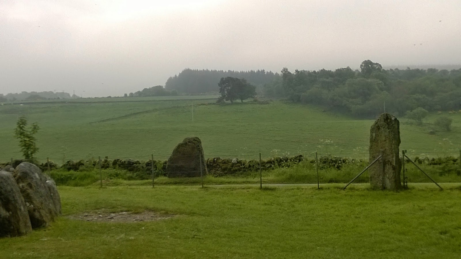
On our recent trip to Scotland, I knew little of Scotland's prehistoric past. It was thrilling to visit this prehistoric burial site with standing stones, which is properly called the Prehistoric Burial Cairns of Balnuaran of Clava.  It's beside a one-lane rural road not far from the Culloden Battlefield. Few people visited it while we were there, making it possible to admire the work that went into building the passage grave below.
S.W. Passage Cairn
 Both passage graves are no more than a metre or so in height, but when originally constructed the cairns are likely to have been around 3m or 10ft in height. But these weren't for mass buryings - only for one or two persons, most likely tribal chiefs. Archaeologist have discovered that under the rubble base of the grounds, there had been farming here; but then someone decided it was the perfect place for his grave. And that was that. This was about 4000 years ago. A couple of thousand years went by and then they were used once more.

There are three cairns, each one was surrounded by standing stones - as many as nine.
Not small standing stones, either, attested by Jay, though the perspective shrinks him.


The stone circle surrounding the South West Passage Grave has that small road going through it, leaving one stone marooned on the far side of the road and another forming part of the fence.


And, yes, the monument is aligned on the midwinter solstice. In recent years this phenomenon has been observed by covering the chamber and passage with tarpaulin. This showed that on a clear day the rays of the setting sun travel down the passage and divide the chamber in half.
A beam of intense light focuses on the back wall. The same effect would have been visible in the south-west cairn where the view is obstructed by a modern farmhouse. So, the Victorians, thinking this had been a druid place, planted trees to give it a wooded look. Which certainly does add to the atmosphere.


With woodland toadstools

What draws your attention toward the end of your walk-around is the split stone (or were two placed against each other originally and have slipped apart?

Who cannot resist having her picture taken between the stones?

When we drove away down that one-lane rural road, we didn't expect to encounter this monumental Victorian engineering feat - the Culloden Viaduct, opened in 1898 as part of the Inverness and Aviemore Direct Railway, built by the Highland Railway.  The 29 span viaduct crosses the wide valley of the River Nairn . At 1800 ft (549 m) in length, it is the longest masonry viaduct in Scotland. It wasn't in my Michelin Guide, so I guess that's part of the joy of traveling - discovering sites you didn' t expect.


Thursday, June 12, 2014

Jay's Take on Scotland (Part 1) - Scottish Independence

My Own Private Idaho: They'll Never Take ... Our Freedom: Scottish flag stone in Ardersier Yesterday, a friend posted on Facebook a photo of Mel Gibson from Braveheart , painted in Pictish blue ...